Total Miles Walked To Date:438.5 Miles
Total Miles Run To Date:365.4Miles
Total Miles Walk/Run To Date: 803.9Miles
Average of 2.48 Miles a Day
Tuesday, July 28, 2009

Sunday, July 19, 2009
Old Erie Canal State Park Trail - July 11, 2009


On the weekend of July 11, 2009 I head to Syracuse for the wedding of my niece Alexandra to John. While I was there I took the opportunity to take a run on the Old Erie Canal State Park Trail, at it's starting point in De Witt, NY. It was a good day for a run, Louis and Vinny joined me for the run, it was a good day for a run but even a better day for the wedding!


The Old Erie Canal State Park Trail is 36 miles long, and links Dewitt with Rome. The park was created from an abandoned section of the original Erie Canal. Almost the entire trail runs along the Old Erie Canal. The trail comes within four miles of Oneida Lake (a major tourist area) a few miles south of Higginsville.There are many things to see and do in both Verona Beach and Rome.
Old Erie Canal Trail Information:
New York State Canal Corporation
800/4CANAL4
Old Erie Canal Trail Links:
New York Canalway Trail System
New York State Canalway Trail System
Old Erie Canal Trail Information:
New York State Canal Corporation
800/4CANAL4
Old Erie Canal Trail Links:
New York Canalway Trail System
New York State Canalway Trail System
The New York State Canalway Trail System is comprised of a network of more than 260 miles of existing multi-use, recreational trails across upstate New York. Major segments are adjacent to the waterways of the New York State Canal System (see our map) or follow remnants of the historic original canals of the early 1800s that preceded today's working Canal System.
The Canalway Trail System is comprised of four major segments: the 100-mile Erie Canal Heritage Trail in Western New York; the 36-mile Old Erie Canal State Park Trail in Central New York; the 60-mile Mohawk-Hudson Bikeway in the eastern Capital Region, and the eight-mile Glens Falls Feeder Canal Heritage Trail in the foothills of the Adirondacks near Lake George. In addition, there are smaller segments of Canalway Trail.
These trail segments and other areas of the Canalway Trail System connect with trails leading throughout New York State, providing one of the most extensive trail networks in the country.
Erie Canal Heritage Trail - a 100-mile Trail between Tonawanda and Newark in Western New York. This Trail segment is designated as a National Recreation Trail and has numerous access points, primarily where local roads intersect. Parking is available at many of the access points. Sign kiosks containing maps and historic information are located at many trailheads. Trail Uses: Hiking, bicycling, cross-country skiing (all sections); horseback riding and snowmobiling in some sections (for details call the Canal Corporation). Trail Surface: Stone dust; some portions in Tonawanda and Rochester are asphalt. Biker-Hiker-Boater Campsites are located at Lock 30 in Macedon and at the Holley Canal Port.
Old Erie Canal State Park Trail - a 36-mile Trail within the linear State Park between DeWitt and Rome in Central New York. Designated as a National Recreation Trail, this segment incorporates an abandoned section of the nineteenth century-era Erie Canal. Parking areas with foot-bridge access to the Trail are located at Poolsbrook and Cedar Bay picnic areas within the park.
Mohawk-Hudson Bikeway - a 60-mile Trail along the Erie Canal and Mohawk River between St. Johnsville and Waterford in the Capital Region. Many sections of this segment were built on former grades of the nineteenth century Erie Canal towpath. The trail is continuous except for a segment between Rotterdam Junction and Amsterdam, a short segment under Interstate Route 87 (Adirondack Northway) in the Town of Colonie, and short segments in Schenectady and Cohoes. The bikeway route is signed along connecting roadways.
The New York State Canal Corporation's long-range goal for the Canalway Trail System is to create a cross-State network of multi-use trails that will span nearly 500 miles across upstate New York, paralleling major portions of the 524-mile New York State Canal System.
When completed over the next several years, the Trail System will provide a means for those who are not boaters to enjoy the beauty and the history found all along New York's Canals. The System will include both urban and rural trails to meet the needs of both visitors and local residents alike.
Completion of the Trail will involve the creation of partnerships between the New York State Canal Corporation and a variety of organizations, including local governments, not-for-profit organizations, other New York State government agencies, and the National Park Service.
Mohawk-Hudson Bikeway - a 60-mile Trail along the Erie Canal and Mohawk River between St. Johnsville and Waterford in the Capital Region. Many sections of this segment were built on former grades of the nineteenth century Erie Canal towpath. The trail is continuous except for a segment between Rotterdam Junction and Amsterdam, a short segment under Interstate Route 87 (Adirondack Northway) in the Town of Colonie, and short segments in Schenectady and Cohoes. The bikeway route is signed along connecting roadways.
Glens Falls Feeder Canal Heritage Trail - an eight-mile Trail between Glens Falls and Fort Edward along the historic Feeder Canal near the Hudson River and Old Champlain Canal. The Trail follows the towpath along the Feeder Canal, which is one of the last surviving sections of the original 1820s Canal System. The Feeder Canal was built in the late 1820s to help maintain the water level in the Champlain Canal, since the section between Fort Ann and Fort Edward was higher than the rest of the Canal. A link between the Feeder Canal Heritage Trail and the Warren County/Bikeway leading to Lake George is signed along connecting roadways in Glens Falls.
WATCH THE CANALWAY TRAIL SYSTEM GROW
The New York State Canal Corporation's long-range goal for the Canalway Trail System is to create a cross-State network of multi-use trails that will span nearly 500 miles across upstate New York, paralleling major portions of the 524-mile New York State Canal System.
When completed over the next several years, the Trail System will provide a means for those who are not boaters to enjoy the beauty and the history found all along New York's Canals. The System will include both urban and rural trails to meet the needs of both visitors and local residents alike.
Completion of the Trail will involve the creation of partnerships between the New York State Canal Corporation and a variety of organizations, including local governments, not-for-profit organizations, other New York State government agencies, and the National Park Service.
FIND THE CANALWAY TRAIL TODAY
A free map of the New York State Canalway Trail System is available from the New York State Canal Corporation. To obtain a copy, or to learn more about the Canalway Trail, call: Toll-free (800)-4CANAL4 or write: New York State Canal Corporation P.O. Box 189 Albany, NY 12201-0189.
HISTORY
One of the longest of the great American canals built in the 19th Century. The Erie Canal extends from the Hudson River to Lake Erie, at Buffalo. The idea was to get goods back and forth from the Great Lakes to New York City (via the Hudson River, which connected with the Erie Canal). The Canal was built between 1817 and 1825 and had paid for itself within 10 years. The building of the Canal also helped settle Michigan, Minnesota, Wisconsin, and other states on the Great Lakes.
One of the longest of the great American canals built in the 19th Century. The Erie Canal extends from the Hudson River to Lake Erie, at Buffalo. The idea was to get goods back and forth from the Great Lakes to New York City (via the Hudson River, which connected with the Erie Canal). The Canal was built between 1817 and 1825 and had paid for itself within 10 years. The building of the Canal also helped settle Michigan, Minnesota, Wisconsin, and other states on the Great Lakes.
At the dawn of the 19th century, New York businessmen were getting anxious. New York was losing out to other port cities as a center for trade. New York offered no easy way -- besides a long, hard, overland trip -- to ship goods between the city and the Midwest, where a growing population wanted to trade.
In 1810, Mayor De Witt Clinton proposed a dramatic solution. He suggested digging a canal between the Hudson River and Lake Erie, one of the Great Lakes. Clinton asked President Madison for financial aid but was rejected. Determined, he persuaded New York State to fund the project, even though some politicians nicknamed it "Clinton's ditch."
Construction began in 1817 and was finished in 1825. The canal was an amazing 363 miles long, but only 40 feet wide and four feet deep. That may sound shallow, but it was deep enough for its flat-bottomed boats. The canal also had 83 stone locks to help raise and lower boats across steep inclines.
In 1825, when the canal was completed, Clinton traveled on the first boat from Buffalo, at the Lake Erie end, to Albany, then on down to Manhattan. When he got there, the city celebrated.
July 19, 2009 Miles Update
Total Miles Run To Date: 353.3 Miles
Total Miles Walked To Date: 425.5 Miles
Total Walk/Run To Date: 778.8 Miles
Sunday, June 7, 2009


REACH - Family Fun Run/Walk/5K


What is REACH
Torne Valley Sports Complex, Suffern, NY
Today's weather and location for a 5K road race was great. The race started at 8:00 AM in the beautiful Torne Valley with the Ramapo Mountains in the background it was a great setting for the race. The Weather was still cool and dry, the course was hilly and a little more challenging than I thought it was going to be. The first mile was mostly down hill, but then we looped around and it was all up hill for over a mile and a half. Thankfully the last half mile was downhill, but all in all, it was a great morning run for this memorial miler!


What is REACH
Founded in 1998, The REACH Foundation of Rockland, Inc. is a not-for-profit organization that raises funds to support innovative educational programs for students and the community at large. The mission of The Reach Foundation is to provide funding for the development and implementation of innovative school and community programs in hope of relieving some of the tax burden and inviting those who may not have children in schools, to utilize the facilities that they help maintain in their annual school tax bill. To this extent, The Reach Foundation has raised monies through state grants, corporate donations, local business owners and community members to fulfill its goals.
Dominican Republic
Punta Cana
NH Real Arena - Bavaro Beach
May 24 - 29, 2009
Family Vacation
Punta Cana, on the eastern tip of the Dominican Republic, is what Caribbean postcards are made of: twenty-five miles of white sand, swaying coconut trees and more than 35 resorts (which by law cannot be taller than a palm tree). European tourists long ago discovered Punta Cana and Americans are now catching on. At this affordable tropical getaway, most guests choose to stay in all-inclusive resorts. The town itself isn't a tourist draw; the primary purpose of Punta Cana is relaxation by the sea.
I managed to run or walk ever day on the beach (tough life), and we did a little sports fishing, kayaking, snorkeling, sunbathing, swimming, eating and drinking. Jim, MB, Adam and Dan joined Sue, Jill, Amanda and me on the trip, we had a blast and it was a great family trip!


Day 287 - June 7, 2009
Miles Run To Date: 302.3 Miles
Miles Walked To Date: 367.0 Miles
Total Miles Walked/Run To Date: 669.3 Miles
Miles Walked To Date: 367.0 Miles
Total Miles Walked/Run To Date: 669.3 Miles
Wednesday, May 20, 2009
AHA Wall Street Run & Heart Walk

American Heart Association Start! Wall Street Run & Heart Walk
May 19, 2009
The Start! Wall Street Run & Heart Walk is a 5K (3.1 mile) competitive run and non-competitive walk to raise awareness and funds to support the American Heart Association's mission to build healthier lives free of cardiovascular diseases and stroke – the nation’s No. 1 and No. 3 killers. Approximately 12,000 people participate in this year's event including Memorial Milers Joan Hamilton, Paul Pietropaolo, Connie Lee and her brother Peter Lee.
The AHA Start! Wall Street Run & Heart Walk traveled a circuitous route through Lower Manhattan, starting on Greenwich Street at Murray Street and finishing on the Esplanade. The exact route is as follows: Head north from the start on Greenwich Street, turn right on Warren Street, right on Church Street, left on Dey Street (becomes John St), right on William Street and continuing down on South William Street, left on Broad Street, left on Pearl Street, right on John Street, right on Water Street (turns into State Street and continues along Battery Park), left on Battery Place, left on Third Place, and right on the Esplanade to the finish near Liberty Street.
More than 27,000 people in New York City alone die from heart disease and stroke each year. At the Start! Wall Street Run and Heart Walk you can visit the Create Hope, Inspire Change and Celebrate Success communities, featuring free health screenings, nutrition and fitness information, resources on heart disease and stroke, product sampling and more.
What is Start?
The Issue Cardiovascular disease is our nation’s No. 1 killer. Physical inactivity significantly increases the risk of heart disease and stroke. Seventy percent of Americans don’t get enough exercise, blaming lack of time and lack of motivation. Ignoring fitness and health increases chances for disease.
The Start! Solution Start! is the American Heart Association’s groundbreaking national campaign that calls on all Americans and their employers to create a culture of physical activity and health to live longer, heart-healthy lives through walking. Promoting physical activity through workplace walking programs can help employees reduce their risk for heart disease and stroke and lead longer, stronger, healthier lives.

Joan and Paul on Broadway, heading to the start of the race.


Joan, Paul, Peter and Connie before the start of the race.

The runners take off!

Paul with the Brooklyn Cyclone mascot at the finish of the race.
Monday, May 18, 2009
Tucson, Arizona
On May 14, 2009 I flew out to Tucson Arizona to pick-up Amanda as she wrapped up her freshman year at The University of Arizona. While I was there I managed to get some runs in and we took a little hike in the Saguaro National Park. Amanda had a great year at the U of A, and she was ready to come home for the summer.


The Saguaro Wilderness Area was officially designated as wilderness in 1976. This large, road less back country consists of 57,930 acres within the Rincon Mountain District of Saguaro National Park. It is bounded on three sides by the 38,590 acre Rincon Mountain Wilderness Area, which lies within the Coronado National Forest. Although these wilderness areas are adjacent to one another, management philosophies differ.
Plant communities within the Saguaro Wilderness Area vary from hot and dry desert scrub to cool and moist pine forest. Six different biotic communities are represented here including: desert scrub, desert grassland, oak woodland, pine-oak woodland, pine forest and mixed conifer forest. This biologically diverse area supports a tremendous variety of plant and animal species. Please help protect this wild and wonderful place; leave all natural and cultural objects as you find them. It’s a great place to visit and if you get to Tucson, you should plan on making your way to this park. 


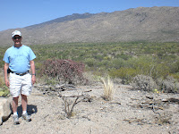


The Saguaro Wilderness Area:

The Saguaro Wilderness Area was officially designated as wilderness in 1976. This large, road less back country consists of 57,930 acres within the Rincon Mountain District of Saguaro National Park. It is bounded on three sides by the 38,590 acre Rincon Mountain Wilderness Area, which lies within the Coronado National Forest. Although these wilderness areas are adjacent to one another, management philosophies differ.
Plant communities within the Saguaro Wilderness Area vary from hot and dry desert scrub to cool and moist pine forest. Six different biotic communities are represented here including: desert scrub, desert grassland, oak woodland, pine-oak woodland, pine forest and mixed conifer forest. This biologically diverse area supports a tremendous variety of plant and animal species. Please help protect this wild and wonderful place; leave all natural and cultural objects as you find them. It’s a great place to visit and if you get to Tucson, you should plan on making your way to this park.


Lodge on the Desert: This where I stayed!

Subscribe to:
Posts (Atom)